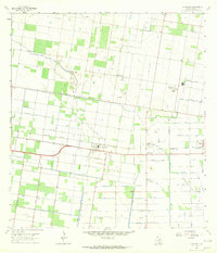
1963 Map of La Blanca
USGS Topo · Published 1965About this map
San Carlos Gas Field and several neighboring extraction zones define the industrial character of this South Texas landscape in the early 1960s. The map shows an intricate network of infrastructure supporting both agriculture and the energy sector, featuring numerous Gas Wells and the Santa Cruz Aqueduct. Small communities like San Carlos, Evergreen, and La Blanca are positioned along the rail lines of the Southern Pacific and Missouri Pacific, highlighting the importance of transport for both local produce and refinery products. Notable technical landmarks including a Refinery, a Filtration Plant, and a Water Tank at Engleman Gardens reveal the engineered nature of the terrain, where drainage systems like the Donna Drain manage the water needs of this productive region.
Find a feature on this map
20 named features on this map. Tap any name to fly to it.
Don’t see what you’re looking for? This feature index may not catch every label — zoom into the map to look around manually.
Map Details
Editions of this 1963 La Blanca Map
2 editions found
Other maps of this area

1914 · San Juan
USGS Topo · 1:48,000

1916 · San Juan
USGS Topo · 1:62,500

1949 · Mc Allen
USGS Topo · 1:250,000

1953 · Brownsville
USGS Topo · 1:250,000

1954 · McAllen
USGS Topo · 1:250,000

1956 · Mercedes
USGS Topo · 1:24,000

1956 · Brownsville
USGS Topo · 1:250,000

1956 · Port Isabel
USGS Topo · 1:250,000
1957 · Lasara
USGS Topo · 1:24,000
1957 · Edcouch
USGS Topo · 1:24,000