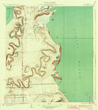
1934 Map of La Coma
USGS Topo · Published 1934About this map
Laguna Madre defines the eastern edge of this coastal landscape, where the shallow waters of the gulf meet a complex network of ancient distributary channels. In the early 1930s, this portion of Cameron County was characterized by these winding resacas, including Resaca de los Cuates and Resaca de la Gringa, which trace the abandoned paths of the Rio Grande across the flat coastal plain. These natural features provided essential drainage and intermittent water sources for early ranching operations like the La Coma Ranch.
Find a feature on this map
12 named features on this map. Tap any name to fly to it.
Don’t see what you’re looking for? This feature index may not catch every label — zoom into the map to look around manually.
Map Details
Editions of this 1934 La Coma Map
3 editions found

Other maps of this area

1929 · La Coma
USGS Topo · 1:24,000

1929 · Point Isabel
USGS Topo · 1:24,000

1929 · Buena Vista
USGS Topo · 1:24,000

1929 · Laguna Vista
USGS Topo · 1:24,000

1930 · Padre Island No. 1
USGS Topo · 1:24,000

1930 · Los Fresnos
USGS Topo · 1:24,000

1930 · La Leona
USGS Topo · 1:24,000

1930 · Padre Island No. 2
USGS Topo · 1:24,000

1930 · Laguna Atascosa
USGS Topo · 1:24,000

1934 · Port Isabel
USGS Topo · 1:31,680