
1934 Map of La Coma
USGS Topo · Published 1934About this map
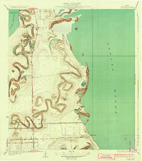
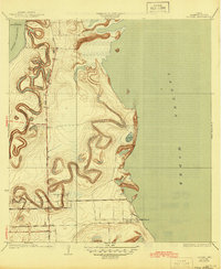
The sinuous channel of Resaca Los Cuates and other distributary waterways define this coastal landscape on the edge of the Laguna Madre. Surveyed in 1929, the topography illustrates the complex hydraulic environment of Cameron County before significant modern development, where ancient river bends formed distinctive resacas like Resaca de la Gringa. Transportation in the region relied on the Missouri Pacific RR and the Buena Vista Road, which connected isolated outposts such as La Coma Ranch and the small settlement of Abney. Along the shoreline, landforms such as Moranco Blanco and Loma la Jauja rise above the wetlands and tidal flats near Holly Beach. County Engineer W.O. Washington and local commissioners provided data for this survey, which documents the critical relationship between the South Texas ranching economy and the natural drainage patterns of the Laguna Atascosa basin.
Find a feature on this map
13 named features on this map. Tap any name to fly to it.
Don’t see what you’re looking for? This feature index may not catch every label — zoom into the map to look around manually.
Map Details
Editions of this 1934 La Coma Map
3 editions found
Other maps of this area

1929 · La Coma
USGS Topo · 1:24,000

1929 · Point Isabel
USGS Topo · 1:24,000

1929 · Buena Vista
USGS Topo · 1:24,000

1929 · Laguna Vista
USGS Topo · 1:24,000

1930 · Padre Island No. 1
USGS Topo · 1:24,000

1930 · Los Fresnos
USGS Topo · 1:24,000

1930 · La Leona
USGS Topo · 1:24,000

1930 · Padre Island No. 2
USGS Topo · 1:24,000

1930 · Laguna Atascosa
USGS Topo · 1:24,000

1934 · Port Isabel
USGS Topo · 1:31,680