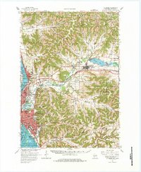
1963 Map of La Crosse
USGS Topo · Published 1984About this map
The Black River and the Mississippi River dominate the western edge of this terrain, where the sprawling Upper Mississippi River Wild Life and Fish Refuge buffers the urban centers of La Crosse and Onalaska. This mid-century landscape is defined by the sharp transition from the river bottoms to the deeply dissected ridges of the driftless area, where numerous coulees like Mormon Coulee and State Road Coulee provide narrow corridors for agriculture and early settlements. The rail infrastructure is dense, with the Chicago Burlington and Quincy and the Chicago Milwaukee St Paul and Pacific railroads converging near Grand Crossing.
Find a feature on this map
134 named features on this map. Tap any name to fly to it.
Don’t see what you’re looking for? This feature index may not catch every label — zoom into the map to look around manually.
Map Details
Editions of this 1963 La Crosse Map
3 editions found
Other maps of this area

1909 · Sparta
USGS Topo · 1:62,500

1923 · Viroqua
USGS Topo · 1:62,500

1926 · Stoddard
USGS Topo · 1:62,500

1926 · Viroqua
USGS Topo · 1:62,500

1926 · North Bend
USGS Topo · 1:62,500

1927 · La Crosse
USGS Topo · 1:62,500

1928 · Melrose
USGS Topo · 1:48,000

1929 · Galesville
USGS Topo · 1:62,500

1929 · North Bend
USGS Topo · 1:62,500

1930 · La Crescent
USGS Topo · 1:62,500