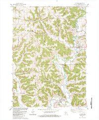
1983 Map of La Farge
USGS Topo · Published 1984About this map
The Kickapoo River winds through the heart of this Driftless Area landscape, anchoring the village of La Farge and the southern settlement of Viola. By the early 1980s, the valley topography was clearly defined by prominent heights like Buckeye Ridge and Buchanan Ridge, while the local transportation history is marked by the winding Old Railroad Grade following the riverbanks. The map reveals a deeply etched agricultural and social fabric, with family-named land features and numerous rural burial grounds such as Salem Ridge Cem and Mt Zion Cem serving as vital links for genealogists. Landmarks like Ft Wales Rock and Indianhead rise above the valleys, while small clusters like Tunnelville and Liberty represent the persistent rural crossroads of Vernon County and Richland County.
Find a feature on this map
93 named features on this map. Tap any name to fly to it.
Don’t see what you’re looking for? This feature index may not catch every label — zoom into the map to look around manually.
Map Details
Editions of this 1983 La Farge Map
This is the sole edition of this map. No revisions or reprints were ever made.
Other maps of this area

1923 · Viroqua
USGS Topo · 1:62,500

1924 · Gays Mills
USGS Topo · 1:62,500

1926 · Gays Mills
USGS Topo · 1:62,500

1926 · Viroqua
USGS Topo · 1:62,500

1926 · La Farge
USGS Topo · 1:62,500

1933 · Boaz
USGS Topo · 1:62,500

1958 · La Crosse
USGS Topo · 1:250,000

1961 · La Crosse
USGS Topo · 1:250,000

1965 · La Crosse
USGS Topo · 1:250,000

1965 · La Farge
USGS Topo · 1:62,500