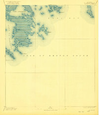
1893 Map of La Fortuna
USGS Topo · Published 1921About this map
Lake La Fortuna and the surrounding marshlands of St. Bernard Parish appear here as they were surveyed in the late nineteenth century. The landscape is dominated by complex coastal waterways and points of land reaching into the Gulf waters, including Gardner Pt and Pt La Fortuna. Navigation through the wetlands is facilitated by features like Canal Fortuna and Pass Fernandea, which connect the interior brackish lakes to the open expanse of Isle Au Breton Sound. The coastal morphology of this era shows a jagged, intricate shoreline where Bayou Terre Aux Boeufs meets Black Bay. This topography, recorded by the U.S. Public Land Office, provides a detailed look at the hydraulic network of the delta prior to the significant coastal erosion and levee modifications of the twentieth century, capturing a time when natural passes like Bayou Frenne Picant were primary features of the local geography.
Find a feature on this map
14 named features on this map. Tap any name to fly to it.
Don’t see what you’re looking for? This feature index may not catch every label — zoom into the map to look around manually.
Map Details
Editions of this 1893 La Fortuna Map
3 editions found
Other maps of this area

1892 · Quarantine
USGS Topo · 1:62,500

1893 · La Fortuna
USGS Topo · 1:62,500

1893 · Forts
USGS Topo · 1:62,500

1893 · Chandeleur
USGS Topo · 1:62,500

1893 · Shell Beach
USGS Topo · 1:62,500

1893 · Dime
USGS Topo · 1:62,500

1895 · Bodreau
USGS Topo · 1:62,500

1935 · Taylor Pass
USGS Topo · 1:31,680

1935 · Morgan Harbor
USGS Topo · 1:31,680

1935 · Lake Athanasio
USGS Topo · 1:31,680