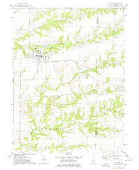
1974 Map of La Harpe
USGS Topo · Published 1978About this map
La Harpe serves as the primary hub of this west-central Illinois landscape, where the grid-patterned streets of the village intersect with the critical corridor of the Toledo Peoria and Western railroad. The map illustrates a rural economy defined by the winding drainages of the La Moine River and its numerous tributaries, including the South Branch La Moine River and Baptist Creek. This 1970s survey captures the region just as modern infrastructure was solidifying, featuring the Landing Field south of town and the recreational development of the Twin Oaks Country Club near Blandinsville. Family history is anchored by several local burial grounds, including Chapel Cem, Hillsborough Cem, and Duncan Cem, which are scattered across the townships of La Harpe, Blandinsville, and Fountain Green. Local landmarks like Mayor Memorial Park and various roadside picnic areas highlight the community's mid-century social spaces.
Find a feature on this map
29 named features on this map. Tap any name to fly to it.
Don’t see what you’re looking for? This feature index may not catch every label — zoom into the map to look around manually.
Map Details
Editions of this 1974 La Harpe Map
This is the sole edition of this map. No revisions or reprints were ever made.
Other maps of this area

1913 · Colchester
USGS Topo · 1:62,500

1918 · La Harpe
USGS Topo · 1:62,500

1932 · Lomax
USGS Topo · 1:62,500

1933 · Carthage
USGS Topo · 1:62,500

1937 · Carthage
USGS Topo · 1:62,500

1937 · Lomax
USGS Topo · 1:62,500

1958 · Burlington
USGS Topo · 1:250,000

1961 · Burlington
USGS Topo · 1:250,000

1963 · Burlington
USGS Topo · 1:250,000

1964 · Lomax
USGS Topo · 1:24,000