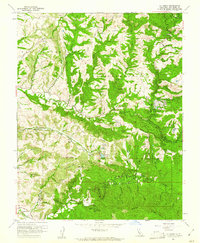
1961 Map of La Honda
USGS Topo · Published 1961About this map
San Gregorio and La Honda anchor this 1961 survey of the Santa Cruz Mountains, illustrating a landscape of specialized camps and coastal canyons. The map documents the educational and recreational development of the era, notably the San Francisco Boys School and the San Francisco Boy Scout Camp, alongside smaller settlements like Redwood Terrace and Loma Mar. Industrial attempts are visible in the scattered Oil Wells and a Drill Hole located near the ridges, suggesting a history of resource exploration amidst the redwood-filled drainages.
Find a feature on this map
67 named features on this map. Tap any name to fly to it.
Don’t see what you’re looking for? This feature index may not catch every label — zoom into the map to look around manually.
Map Details
Editions of this 1961 La Honda Map
4 editions found
Other maps of this area

1897 · Palo Alto
USGS Topo · 1:62,500

1899 · Palo Alto
USGS Topo · 1:62,500

1902 · Santa Cruz
USGS Topo · 1:125,000

1940 · Halfmoon Bay
USGS Topo · 1:62,500

1940 · Ano Nuevo
USGS Topo · 1:62,500

1941 · Ano Nuevo Pt.
USGS Topo · 1:62,500

1941 · Palo Alto
USGS Topo · 1:62,500

1942 · Ano Nuevo
USGS Topo · 1:62,500

1943 · Palo Alto
USGS Topo · 1:62,500

1943 · Halfmoon Bay
USGS Topo · 1:62,500