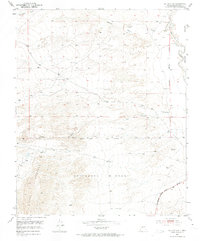
1952 Map of La Joya NW
USGS Topo · Published 1974About this map
Sevilleta Grant land occupies much of this high desert landscape as it appeared in the early 1950s. The map illustrates the convergence of ancient and modern transportation routes in the southeast corner, where the historic El Camino Real shares a corridor with the Pan American Central Highway. This area is characterized by significant topographic relief, most notably the eastern slopes of the Sierra Ladrones rising in the southwest. The New Mexico Principal Meridian serves as a critical surveying boundary, separating the grant lands from the Belen Grant to the east. Water resources are sparse, marked only by intermittent features like Mariano Draw, Cañada Colorado, and the Rio Puerco, along with scattered windmills and storage tanks that indicate the vital infrastructure required for ranching in this arid New Mexico terrain.
Find a feature on this map
15 named features on this map. Tap any name to fly to it.
Don’t see what you’re looking for? This feature index may not catch every label — zoom into the map to look around manually.
Map Details
Editions of this 1952 La Joya NW Map
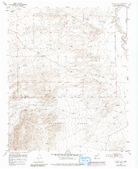
Other maps of this area

1916 · La Joya
USGS Topo · 1:125,000

1917 · Cerro Verde
USGS Topo · 1:125,000

1952 · La Joya NW
USGS Topo · 1:24,000

1952 · San Anacia
USGS Topo · 1:24,000

1952 · Belen SW
USGS Topo · 1:24,000

1952 · La Joya
USGS Topo · 1:24,000

1952 · Veguita
USGS Topo · 1:24,000

1952 · Abeytas
USGS Topo · 1:24,000

1954 · Socorro
USGS Topo · 1:250,000

1956 · Mesa Aparejo
USGS Topo · 1:62,500