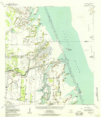
1955 Map of La Leona
USGS Topo · Published 1957About this map
Los Coyotes Ranch and Rancho Nuevo anchor this coastal landscape in the mid-1950s, representing the traditional ranching heritage of the South Texas brush country. Situated in the Laguna Madre region of Cameron County, the area is defined by its complex hydrology where the land meets the shallow coastal lagoons. The map reveals a transition from inland ranching operations to the intricate network of tidal flats and coastal prairies. This document, compiled from several specialized surveys, captures the spatial arrangement of rural life before significant late-century development, providing a clear record of the family-named ranching outposts that once dominated the coastal plains near the gulf.
Find a feature on this map
2 named features on this map. Tap any name to fly to it.
Don’t see what you’re looking for? This feature index may not catch every label — zoom into the map to look around manually.
Map Details
Editions of this 1955 La Leona Map
2 editions found
Other maps of this area

1921 · Tarida Ranch
USGS Topo · 1:62,500

1929 · Rio Hondo
USGS Topo · 1:24,000

1929 · La Coma
USGS Topo · 1:24,000

1929 · Buena Vista
USGS Topo · 1:24,000

1930 · Padre Island No. 1
USGS Topo · 1:24,000

1930 · La Leona
USGS Topo · 1:24,000

1930 · Padre Island No. 2
USGS Topo · 1:24,000

1930 · Laguna Atascosa
USGS Topo · 1:24,000

1932 · Rio Hondo
USGS Topo · 1:31,680

1933 · Paso Real
USGS Topo · 1:31,680
Featured Places
- Coulson Colonia, TX
- Rancho Nuevo, TX
- Arroyo City Subdivision Colonia, TX
- La Leona, TX
- Los Coyotes Ranch, TX