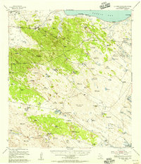
1955 Map of La Parra Ranch
USGS Topo · Published 1956About this map
Artesian wells and shifting dunes define this South Texas landscape along the shores of Baffin Bay. The map reveals a sophisticated ranching infrastructure focused on water access, with family-named sources like Santiago Artesian Well, Mota Negra Artesian Well, and the Santiago Artesian Well scattered across the arid terrain. Large cattle operations center on La Parra Ranch and Los Indios Ranch, separated by miles of private fencing and a network of windmills.
Find a feature on this map
74 named features on this map. Tap any name to fly to it.
Don’t see what you’re looking for? This feature index may not catch every label — zoom into the map to look around manually.
Map Details
Editions of this 1955 La Parra Ranch Map
This is the sole edition of this map. No revisions or reprints were ever made.
Other maps of this area

1923 · Armstrong
USGS Topo · 1:62,500

1923 · Lopena Island
USGS Topo · 1:62,500

1923 · Saltillo Ranch
USGS Topo · 1:62,500

1928 · Sarita
USGS Topo · 1:125,000

1950 · Corpus Christi
USGS Topo · 1:250,000

1951 · Point Of Rocks
USGS Topo · 1:24,000

1951 · Kleberg Point
USGS Topo · 1:24,000

1951 · Potrero Lopeno NW
USGS Topo · 1:24,000

1951 · Sarita 4 NE
USGS Topo · 1:24,000

1951 · South Bird Island
USGS Topo · 1:62,500