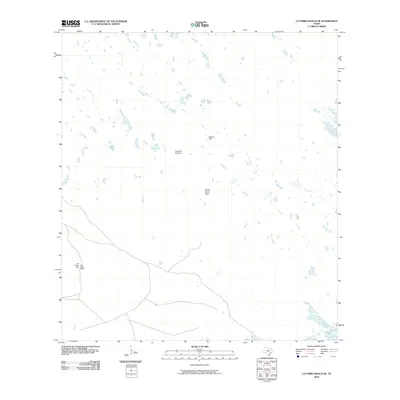
2010 Map of La Parra Ranch SE
USGS Topo · Published 2010About this map
Los Indios Ranch anchors this portion of Kenedy County, illustrating the isolated ranching landscape of South Texas at the turn of the 21st century. The terrain is defined by its dependency on water infrastructure, evidenced by scattered landmarks like Agujon Well and the Los Indios Well located near the ranch headquarters. A network of unimproved roads and trails connects these remote outposts, tracing paths through a landscape punctuated by functional ranching features such as the Santa Elena Trap. The presence of the Chaparral Windmill further emphasizes the necessity of wind-powered water extraction in this arid environment. This 2010 survey by the U.S. Geological Survey captures the enduring cattle-country character of the region, where family-named sites and essential wells remain the primary geographic markers.
Find a feature on this map
5 named features on this map. Tap any name to fly to it.
Don’t see what you’re looking for? This feature index may not catch every label — zoom into the map to look around manually.
Map Details
Editions of this 2010 La Parra Ranch SE Map
This is the sole edition of this map. No revisions or reprints were ever made.
Other maps of this area

1923 · Lopena Island
USGS Topo · 1:62,500

1923 · Saltillo Ranch
USGS Topo · 1:62,500

1928 · Sarita
USGS Topo · 1:125,000

1950 · Corpus Christi
USGS Topo · 1:250,000

1951 · Potrero Lopeno NW
USGS Topo · 1:24,000

1951 · Sarita 4 NE
USGS Topo · 1:24,000

1952 · Potrero Cortado
USGS Topo · 1:24,000

1952 · La Parra Ranch
USGS Topo · 1:24,000

1952 · Yarborough Pass
USGS Topo · 1:24,000

1952 · Sarita 4 SE
USGS Topo · 1:24,000