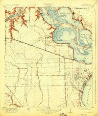
1920 Map of La Porte
USGS Topo · Published 1925About this map
The San Jacinto Battlefield occupies the strategic confluence of the San Jacinto River and Buffalo Bayou, marking the historic grounds of Texas independence on this 1916 survey. The coastal landscape is defined by a complex network of bays, including Scott Bay, Black Duck Bay, and San Jacinto Bay, which are navigated by the newly emerging industrial artery of the Houston Ship Channel. This era shows La Porte as a settled coastal hub with a dedicated La Porte Sta, connected to the interior via the Southern Pacific System. Inland, the terrain transitions to prairies drained by Big Island Slough and Willow Gully, where small rural centers like Lomax School and the early settlement of Deer Park appear before the mid-century industrial boom transformed the Upper Texas Coast.
Find a feature on this map
47 named features on this map. Tap any name to fly to it.
Don’t see what you’re looking for? This feature index may not catch every label — zoom into the map to look around manually.
Map Details
Editions of this 1920 La Porte Map
3 editions found

Other maps of this area

1915 · Deepwater
USGS Topo · 1:24,000

1916 · Genoa
USGS Topo · 1:24,000

1916 · Burnett Bay
USGS Topo · 1:24,000

1916 · Morgan Point
USGS Topo · 1:24,000

1916 · Seabrook
USGS Topo · 1:24,000

1916 · Fauna
USGS Topo · 1:24,000

1916 · Cedar Bayou
USGS Topo · 1:24,000

1916 · La Porte
USGS Topo · 1:24,000

1919 · Morgan Point
USGS Topo · 1:31,680

1919 · Deepwater
USGS Topo · 1:31,680