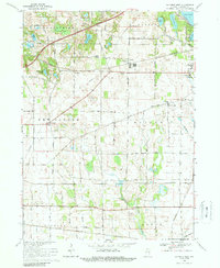
1969 Map of La Porte West
USGS Topo · Published 1988About this map
Pinhook Bog and the distinctive diagonal of the Indian Treaty Boundary define the landscape west of La Porte at the end of the 1960s. This survey illustrates a complex web of transportation, where five different railroads—including the Penn Central, Norfolk and Western, and Grand Trunk—crisscross the prairie and glacial lake country. Small rural centers like Pinola, Pinhook, and Door Village serve as anchors for local life, supported by community institutions such as Carmel Chapel Cem, Township Sch, and the Pinhook Church. To the northeast, the outskirts of the county seat reach toward Pine Lake and Stone Lake, while the La Porte Fair Grounds and Soldiers Memorial Park provide glimpses into the region's social and recreational history. The numerous small bodies of water, such as Hildebrand Lake and Swede Lake, highlight the glaciated terrain typical of Northern Indiana.
Find a feature on this map
42 named features on this map. Tap any name to fly to it.
Don’t see what you’re looking for? This feature index may not catch every label — zoom into the map to look around manually.
Map Details
Editions of this 1969 La Porte West Map
3 editions found
Other maps of this area

1953 · Wanatah
USGS Topo · 1:24,000

1953 · Westville
USGS Topo · 1:24,000

1953 · Michigan City West
USGS Topo · 1:24,000

1953 · Chicago
USGS Topo · 1:250,000

1957 · Chicago
USGS Topo · 1:250,000

1958 · Hanna
USGS Topo · 1:24,000

1958 · Kingsford Heights
USGS Topo · 1:24,000

1958 · Michigan City East
USGS Topo · 1:24,000

1958 · La Porte East
USGS Topo · 1:24,000

1958 · Springville
USGS Topo · 1:24,000