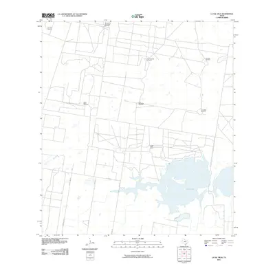
2010 Map of La Sal Vieja
USGS Topo · Published 2010About this map
The salt lake La Sal Vieja dominates this southern Texas landscape, serving as a primary geographical anchor in Hidalgo County. This 2010 survey reveals a rural territory defined by cattle ranching and essential water infrastructure, where named windmills like San Jose de los Llantos Windmill, Jesus Maria Windmill, and San Leonardo Windmill mark critical points across the flat brushland. These features, often named for individuals or traditional Spanish titles, highlight the localized nature of settlement and the necessity of groundwater in this arid environment. Near the shoreline, the La Sal Vieja Ranch stands as a testament to the area's agricultural heritage. The rectilinear grid of roads, including County Line Rd and Roland Rd, illustrates the systematic division of land between large ranching tracts, preserving a pattern of development that has persisted for decades in the Rio Grande Valley hinterlands.
Find a feature on this map
14 named features on this map. Tap any name to fly to it.
Don’t see what you’re looking for? This feature index may not catch every label — zoom into the map to look around manually.
Map Details
Editions of this 2010 La Sal Vieja Map
This is the sole edition of this map. No revisions or reprints were ever made.
Other maps of this area

1922 · La Sal Vieja
USGS Topo · 1:62,500

1939 · Linn
USGS Topo · 1:62,500

1949 · Mc Allen
USGS Topo · 1:250,000

1953 · Brownsville
USGS Topo · 1:250,000

1954 · McAllen
USGS Topo · 1:250,000

1956 · Rudolph
USGS Topo · 1:24,000

1956 · Andrea Ranch
USGS Topo · 1:24,000

1956 · La Sal Vieja
USGS Topo · 1:24,000

1956 · Yturria
USGS Topo · 1:24,000
1956 · Raymondville
USGS Topo · 1:24,000