
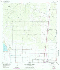
1956 Map of Yturria
USGS Topo · Published 1958About this map
The Missouri Pacific railroad corridor serves as the primary north-south artery for this South Texas landscape, where the boundary between Kenedy and Willacy Counties meets a rugged network of ranching and early energy development. The settlement of Yturria stands as a focal point near the rail line, surrounded by numerous family-named landmarks such as Garcia Ranch, Thomas Ranch, and La Chata Ranch. Water management is the defining characteristic of this arid terrain, evidenced by a dense distribution of windmills including Año Nuevo Windmill, Artesiano Windmill, and Laguna Panda Windmill. To the south, the landscape shifts toward irrigated agriculture, marked by the West Main Drain, an Elevated Ditch, and Spoil Bank features. Notable early industrial markers like an Oil Well and Gas Well appear alongside the expansive La Sal Vieja salt lake, illustrating the intersection of natural resources and commercial expansion in the mid-1950s.
Find a feature on this map
29 named features on this map. Tap any name to fly to it.
Don’t see what you’re looking for? This feature index may not catch every label — zoom into the map to look around manually.
Map Details
Editions of this 1956 Yturria Map
2 editions found
Other maps of this area

1921 · Tarida Ranch
USGS Topo · 1:62,500

1922 · La Sal Vieja
USGS Topo · 1:62,500

1953 · Brownsville
USGS Topo · 1:250,000

1956 · Rudolph
USGS Topo · 1:24,000

1956 · Andrea Ranch
USGS Topo · 1:24,000

1956 · San Perlita South
USGS Topo · 1:24,000

1956 · Rosita Lake
USGS Topo · 1:24,000

1956 · La Sal Vieja
USGS Topo · 1:24,000

1956 · San Perlita North
USGS Topo · 1:24,000
1956 · Raymondville
USGS Topo · 1:24,000