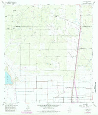
1956 Map of Yturria
USGS Topo · Published 1984About this map
The sprawling salt lake of La Sal Vieja dominates the southwestern corner of this landscape, marking a distinct geographical transition in the South Texas brush country. As recorded in the 1950s with later revisions, the region is defined by a network of large ranching estates, including Garcia Ranch, Thomas Ranch, and Esperanza Ranch. Water management is central to life here, evidenced by the numerous specialized wells like Los Cedros Artesian Wells and Laguna Panda Windmill scattered across the terrain. Along the eastern edge, the Missouri Pacific railroad corridor serves the settlement of Yturria, anchoring the local transport economy. To the south, a more engineered landscape emerges with the West Main Drain, East Main Drain, and Spoil Banks, illustrating the extensive irrigation and drainage efforts required to maintain productivity in the Willacy County plains.
Find a feature on this map
33 named features on this map. Tap any name to fly to it.
Don’t see what you’re looking for? This feature index may not catch every label — zoom into the map to look around manually.
Map Details
Editions of this 1956 Yturria Map
2 editions found
Other maps of this area

1921 · Tarida Ranch
USGS Topo · 1:62,500

1922 · La Sal Vieja
USGS Topo · 1:62,500

1953 · Brownsville
USGS Topo · 1:250,000

1956 · Rudolph
USGS Topo · 1:24,000

1956 · Andrea Ranch
USGS Topo · 1:24,000

1956 · San Perlita South
USGS Topo · 1:24,000

1956 · Rosita Lake
USGS Topo · 1:24,000

1956 · La Sal Vieja
USGS Topo · 1:24,000

1956 · San Perlita North
USGS Topo · 1:24,000

1956 · Yturria
USGS Topo · 1:24,000