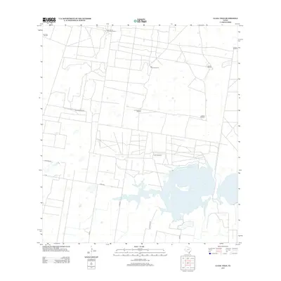
2013 Map of La Sal Vieja
USGS Topo · Published 2013About this map
La Sal Vieja, an expansive hypersaline lake, dominates the hydrology of this South Texas landscape. The surrounding terrain is defined by an intricate network of rural roads and numerous named windmills, which signify the historical and ongoing importance of groundwater management in this arid region. These features, such as San Jose de los Llantos Windmill and Juan Barrientos Windmill, are often tied to specific families or ranching operations. The presence of the La Sal Vieja Ranch near the lakeshore highlights the legacy of large-scale landholdings in Hidalgo County. This survey reflects the persistence of traditional ranching infrastructure alongside modern road designations like Cord 30 N and Garza Ranch Rd, illustrating a landscape where historical water-access points remain the primary named landmarks in a sparsely settled territory.
Find a feature on this map
17 named features on this map. Tap any name to fly to it.
Don’t see what you’re looking for? This feature index may not catch every label — zoom into the map to look around manually.
Map Details
Editions of this 2013 La Sal Vieja Map
This is the sole edition of this map. No revisions or reprints were ever made.
Other maps of this area

1922 · La Sal Vieja
USGS Topo · 1:62,500

1939 · Linn
USGS Topo · 1:62,500

1949 · Mc Allen
USGS Topo · 1:250,000

1953 · Brownsville
USGS Topo · 1:250,000

1954 · McAllen
USGS Topo · 1:250,000

1956 · Rudolph
USGS Topo · 1:24,000

1956 · Andrea Ranch
USGS Topo · 1:24,000

1956 · La Sal Vieja
USGS Topo · 1:24,000

1956 · Yturria
USGS Topo · 1:24,000
1956 · Raymondville
USGS Topo · 1:24,000