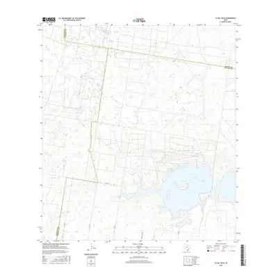
2016 Map of La Sal Vieja
USGS Topo · Published 2016About this map
La Sal Vieja dominates the southeastern portion of this landscape, its waters surrounded by low-lying wetlands and brush typical of this South Texas region. The geography here is defined by the convergence of three counties, with boundaries for Hidalgo, Kenedy, and Willacy counties meeting in the open terrain. This survey illustrates a rural infrastructure of named ranch roads and county lines, such as Garza Ranch Rd and Co Line Rd, which serve the expansive properties and limited agricultural clearings. The map documents the persistent nature of these isolated water bodies and the network of unpaved and secondary routes like Co Rd 3750 and G I Rd that cross the sandy soils and scrubland of the Rio Grande Valley hinterlands.
Find a feature on this map
11 named features on this map. Tap any name to fly to it.
Don’t see what you’re looking for? This feature index may not catch every label — zoom into the map to look around manually.
Map Details
Editions of this 2016 La Sal Vieja Map
This is the sole edition of this map. No revisions or reprints were ever made.
Other maps of this area

1922 · La Sal Vieja
USGS Topo · 1:62,500

1939 · Linn
USGS Topo · 1:62,500

1949 · Mc Allen
USGS Topo · 1:250,000

1953 · Brownsville
USGS Topo · 1:250,000

1954 · McAllen
USGS Topo · 1:250,000

1956 · Rudolph
USGS Topo · 1:24,000

1956 · Andrea Ranch
USGS Topo · 1:24,000

1956 · La Sal Vieja
USGS Topo · 1:24,000

1956 · Yturria
USGS Topo · 1:24,000
1956 · Raymondville
USGS Topo · 1:24,000