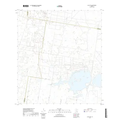
2019 Map of La Sal Vieja
USGS Topo · Published 2019About this map
La Sal Vieja, a large salt lake in South Texas, dominates the southeastern portion of this 2019 survey. The landscape is defined by the convergence of three counties—Hidalgo, Kenedy, and Willacy—with political boundaries cutting across the arid terrain and water. The road network is sparse, consisting primarily of rural routes like Co Line Rd and Garza Ranch Rd, which reflect the ranching heritage and isolated nature of the region. The topography near the lake shore includes small islands and marshy wetlands, while the surrounding area is marked by a grid of local connectors such as Co Rd 20 and Co Rd 3750. This map provides a clear record of the salt lake's shoreline and the rural transportation infrastructure serving the remote ranch lands at the southern tip of the state.
Find a feature on this map
11 named features on this map. Tap any name to fly to it.
Don’t see what you’re looking for? This feature index may not catch every label — zoom into the map to look around manually.
Map Details
Editions of this 2019 La Sal Vieja Map
This is the sole edition of this map. No revisions or reprints were ever made.
Other maps of this area

1922 · La Sal Vieja
USGS Topo · 1:62,500

1939 · Linn
USGS Topo · 1:62,500

1949 · Mc Allen
USGS Topo · 1:250,000

1953 · Brownsville
USGS Topo · 1:250,000

1954 · McAllen
USGS Topo · 1:250,000

1956 · Rudolph
USGS Topo · 1:24,000

1956 · Andrea Ranch
USGS Topo · 1:24,000

1956 · La Sal Vieja
USGS Topo · 1:24,000

1956 · Yturria
USGS Topo · 1:24,000
1956 · Raymondville
USGS Topo · 1:24,000