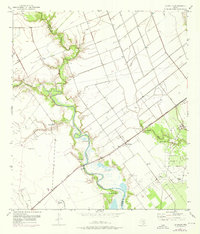
1952 Map of La Salle
USGS Topo · Published 1976About this map
Garcitas Creek meanders deeply through the coastal plains of South Texas, defining much of the boundary between Victoria and Jackson Counties. This landscape is marked by the industrial infrastructure of the early 1950s, with extensive Oil Field operations, numerous Oil Wells, and a dedicated Oil Well scattered across the prairie. The small settlement of La Salle serves as a central point along the dual rail lines of the Missouri Pacific and the St Louis Brownsville and Mexico. The map details a complex system of water management and resource extraction, featuring several instances of a Flowing Well and an intricate network of a Levee and Pipeline. Tributaries such as Arenosa Creek, Venado Creek, and Kentucky Mutt Cr feed into the primary basin, reflecting the hydraulic character of this ranching and petroleum-producing region.
Find a feature on this map
18 named features on this map. Tap any name to fly to it.
Don’t see what you’re looking for? This feature index may not catch every label — zoom into the map to look around manually.
Map Details
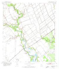
Editions of this 1952 La Salle Map
Other maps of this area

1951 · Inez
USGS Topo · 1:24,000

1952 · Manson
USGS Topo · 1:24,000

1952 · Point Comfort
USGS Topo · 1:24,000

1952 · Edna
USGS Topo · 1:24,000

1952 · Kamey
USGS Topo · 1:24,000

1952 · La Salle
USGS Topo · 1:24,000

1952 · Marcado Creek
USGS Topo · 1:24,000

1952 · Placedo
USGS Topo · 1:24,000

1952 · Lolita
USGS Topo · 1:24,000

1953 · Beeville
USGS Topo · 1:250,000