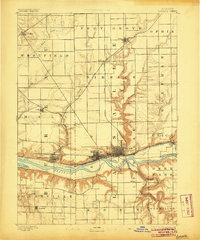
1893 Map of La Salle
USGS Topo · Published 1905About this map
Illinois River commerce dominates this late 19th-century survey, revealing the critical intersection of water and rail transport at the height of the industrial era. The Illinois and Michigan Canal runs parallel to the river, serving as a legacy of earlier transportation before the massive expansion of the Illinois Central Railroad and the Chicago Rock Island and Pacific Railroad which now stitch together the riverfront cities of La Salle, Peru, and Spring Valley. The landscape is defined by the sharp transition between the flat upland prairies and the deeply eroded bluffs and ravines of the Vermilion River and Tomahawk Creek drainage systems. This 1891 topography captures the dense street grids of growing industrial centers alongside smaller agricultural hubs like Arlington and Utica, while the presence of Mud Lake and numerous tributary creeks such as Negro Creek and Spring Creek illustrate the complex hydrology that influenced the region's development.
Find a feature on this map
40 named features on this map. Tap any name to fly to it.
Don’t see what you’re looking for? This feature index may not catch every label — zoom into the map to look around manually.
Map Details
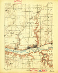
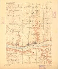
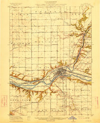
Editions of this 1893 La Salle Map
4 editions found
Other maps of this area

1892 · Ottawa
USGS Topo · 1:62,500

1893 · Lacon
USGS Topo · 1:62,500

1893 · Hennepin
USGS Topo · 1:62,500

1893 · Lasalle
USGS Topo · 1:62,500

1909 · Hennepin
USGS Topo · 1:62,500

1911 · La Salle
USGS Topo · 1:62,500

1911 · Hennepin
USGS Topo · 1:62,500

1913 · La Salle
USGS Topo · 1:62,500
1915 · Ottawa
USGS Topo · 1:62,500

1925 · Streator
USGS Topo · 1:62,500