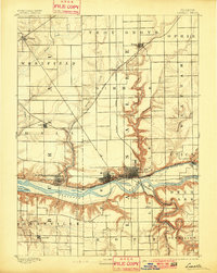
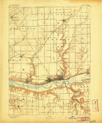
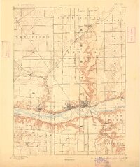
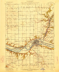
1893 Map of La Salle
USGS Topo · Published 1901About this map
The Illinois River serves as the industrial and transportation spine for this region, flanked by the growing manufacturing and shipping hubs of La Salle and Peru. Surveyed in the 1890s, the map illustrates a complex convergence of rail and water infrastructure, including the historic Illinois and Michigan Canal and major lines like the Chicago Rock Island and Pacific Railroad. The landscape is characterized by the stark contrast between the flat upland prairies and the deeply incised bluffs of the river valleys. To the south, the Vermilion River snakes through the terrain toward Deer Park, while the northern reaches show early rail settlements such as Arlington and Dimmick. This survey captures the height of the coal and canal era, evidenced by the dense grid layouts of towns like Spring Valley and Ladd, which were instrumental to the state's late 19th-century industrial expansion.
Find a feature on this map
39 named features on this map. Tap any name to fly to it.
Don’t see what you’re looking for? This feature index may not catch every label — zoom into the map to look around manually.
Map Details
Editions of this 1893 La Salle Map
4 editions found
Other maps of this area

1892 · Ottawa
USGS Topo · 1:62,500

1893 · Lacon
USGS Topo · 1:62,500

1893 · Hennepin
USGS Topo · 1:62,500

1893 · Lasalle
USGS Topo · 1:62,500

1909 · Hennepin
USGS Topo · 1:62,500

1911 · La Salle
USGS Topo · 1:62,500

1911 · Hennepin
USGS Topo · 1:62,500

1913 · La Salle
USGS Topo · 1:62,500
1915 · Ottawa
USGS Topo · 1:62,500

1925 · Streator
USGS Topo · 1:62,500