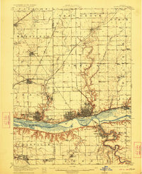
1913 Map of La Salle
USGS Topo · Published 1922About this map
Industrial hubs and coal-mining settlements define this landscape along the Illinois River at the height of the region's transport evolution. The twin cities of La Salle and Peru serve as the primary focus, where the historic Illinois and Michigan Canal parallels the river and a dense web of rail lines, including the Chicago Rock Island and Pacific RR. The area’s educational and religious roots are visible at St Bedes College, while the surrounding townships are dotted with family-named schools like the Aitkin School and Waltham School. To the south, the terrain shifts toward the dramatic bluffs of Deer Park and the burgeoning mining operations near Standard Taft PO and Cedar Point. This survey captures the complex transition from a canal-based economy to a heavy rail-and-industry network before the modern highway era reshaped the Illinois Valley.
Find a feature on this map
76 named features on this map. Tap any name to fly to it.
Don’t see what you’re looking for? This feature index may not catch every label — zoom into the map to look around manually.
Map Details
Editions of this 1913 La Salle Map
4 editions found
Other maps of this area

1892 · Ottawa
USGS Topo · 1:62,500

1893 · Lacon
USGS Topo · 1:62,500

1893 · Hennepin
USGS Topo · 1:62,500

1893 · Lasalle
USGS Topo · 1:62,500

1909 · Hennepin
USGS Topo · 1:62,500

1911 · La Salle
USGS Topo · 1:62,500

1911 · Hennepin
USGS Topo · 1:62,500

1913 · La Salle
USGS Topo · 1:62,500

1915 · Ottawa
USGS Topo · 1:62,500

1925 · Streator
USGS Topo · 1:62,500