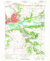
1966 Map of La Salle
USGS Topo · Published 1968About this map
Industrial and educational hubs define the landscape of La Salle, Peru, and Oglesby in the mid-1960s. The confluence of the Illinois River and Vermilion River serves as a pivot point for heavy rail activity, featuring lines of the Chicago Rock Island and Pacific and the Chicago Burlington and Quincy. The presence of La Salle-Peru-Oglesby Jr College and several parochial institutions like St Hyacinth Sch and St Roch Sch highlights the civic development of these riverfront communities.
Find a feature on this map
53 named features on this map. Tap any name to fly to it.
Don’t see what you’re looking for? This feature index may not catch every label — zoom into the map to look around manually.
Map Details
Editions of this 1966 La Salle Map
3 editions found
Other maps of this area

1892 · Ottawa
USGS Topo · 1:62,500

1893 · Lasalle
USGS Topo · 1:62,500

1911 · La Salle
USGS Topo · 1:62,500

1913 · La Salle
USGS Topo · 1:62,500

1915 · Ottawa
USGS Topo · 1:62,500

1925 · Streator
USGS Topo · 1:62,500

1927 · Streator
USGS Topo · 1:62,500

1934 · Wenona
USGS Topo · 1:48,000

1939 · Wenona
USGS Topo · 1:62,500

1946 · Ottawa
USGS Topo · 1:62,500