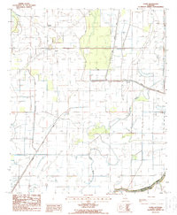
1988 Map of Laark
USGS Topo · Published 1988About this map
Agricultural and hydrological engineering defines the landscape of Morehouse Parish and West Carroll Parish in the late twentieth century. The Boeuf River and Bayou Coffee wind through a complex system of drainage and transport infrastructure, including several segments of Rd On Levee. Smaller settlements like Laark and McGinty anchor this rural region, where family history is marked by small local cemeteries, such as the Cem located near the northern border. The terrain is characterized by its reliance on water management, evidenced by the numerous pipelines and a Pumping Station near the center of the survey. For those interested in recreation or local geography, Crane Lake and a Boat Ramp on the river offer insights into the late-1980s land use patterns in this corner of Louisiana.
Find a feature on this map
11 named features on this map. Tap any name to fly to it.
Don’t see what you’re looking for? This feature index may not catch every label — zoom into the map to look around manually.
Map Details
Editions of this 1988 Laark Map
This is the sole edition of this map. No revisions or reprints were ever made.
Other maps of this area

1935 · Wilmot
USGS Topo · 1:62,500

1935 · Oak Grove
USGS Topo · 1:62,500

1935 · Bonita
USGS Topo · 1:62,500

1936 · Eudora
USGS Topo · 1:62,500

1953 · Greenwood
USGS Topo · 1:250,000

1955 · Jackson
USGS Topo · 1:250,000

1956 · Greenwood
USGS Topo · 1:250,000

1957 · Eudora
USGS Topo · 1:62,500

1958 · Oak Grove
USGS Topo · 1:62,500

1958 · Bonita
USGS Topo · 1:62,500