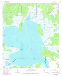
1962 Map of Lac Des Allemands
USGS Topo · Published 1981About this map
Lac Des Allemands dominates this coastal landscape, where the waters of St. John the Baptist and St. Charles Parishes meet. The 1962 topography, updated with late-1970s aerial data, reveals a complex network of bayous and man-made alterations supporting the local energy industry. The Lac Des Allemands Gas Field and Lucy Gas Field are prominent, accompanied by various gas wells, oil wells, and pipelines that cut through the marsh.
Find a feature on this map
29 named features on this map. Tap any name to fly to it.
Don’t see what you’re looking for? This feature index may not catch every label — zoom into the map to look around manually.
Map Details
Editions of this 1962 Lac Des Allemands Map
3 editions found
Other maps of this area

1891 · Hahnville
USGS Topo · 1:62,500

1892 · Lac Des Allemands
USGS Topo · 1:62,500

1892 · Mount Airy
USGS Topo · 1:62,500

1892 · Bonnet Carre
USGS Topo · 1:62,500

1932 · Lac Des Allemands NW
USGS Topo · 1:31,680

1932 · Lac Des Allemands SE
USGS Topo · 1:31,680

1932 · Lac Des Allemands SW
USGS Topo · 1:31,680

1932 · Hahnville NW
USGS Topo · 1:31,680

1932 · Lac Des Allemands NE
USGS Topo · 1:31,680

1932 · Hahnville SW
USGS Topo · 1:31,680