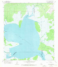
1962 Map of Lac Des Allemands
USGS Topo · Published 1971About this map
Lac Des Allemands dominates this landscape at the intersection of St. John the Baptist, St. Charles, and Lafourche Parishes. In the early 1960s, this watery expanse served as a vital hub for natural resource extraction, evidenced by the Lucy Gas Field and the Lac Des Allemands Gas Field. The map reveals a complex network of artificial waterways like Moll Canal and Little Pecan Tree Canal, which cut through the marsh to facilitate drainage and transport. Landmarks such as Pointe aux Herbes and Carlin Pointe define the shoreline, while named inlets like Baie d'en Haut and Knight Bay reflect the French heritage of the region. The intricate drainage patterns of Bayou Chevreuil and Bayou Lasseigne illustrate the transitional nature of the Louisiana wetlands before further modern development altered these traditional bayou routes.
Find a feature on this map
32 named features on this map. Tap any name to fly to it.
Don’t see what you’re looking for? This feature index may not catch every label — zoom into the map to look around manually.
Map Details
Editions of this 1962 Lac Des Allemands Map
3 editions found
Other maps of this area

1891 · Hahnville
USGS Topo · 1:62,500

1892 · Lac Des Allemands
USGS Topo · 1:62,500

1892 · Mount Airy
USGS Topo · 1:62,500

1892 · Bonnet Carre
USGS Topo · 1:62,500

1932 · Lac Des Allemands NW
USGS Topo · 1:31,680

1932 · Lac Des Allemands SE
USGS Topo · 1:31,680

1932 · Lac Des Allemands SW
USGS Topo · 1:31,680

1932 · Hahnville NW
USGS Topo · 1:31,680

1932 · Lac Des Allemands NE
USGS Topo · 1:31,680

1932 · Hahnville SW
USGS Topo · 1:31,680