
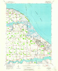
1952 Map of Lacarne
USGS Topo · Published 1953About this map
Lake Erie defines the northern shoreline of this Ottawa County coastal landscape, where the marshy terrain between the Toussaint River and Portage River has been extensively modified for military and industrial use by the early 1950s. The sprawling Erie Ordnance Depot and adjacent Camp Perry dominate the eastern marshes, complete with numerous Observation Towers positioned for shoreline monitoring. Local history and genealogy are preserved in small community markers like Locust Point Cem and Rushow Cem, while the New York Central railroad provides the primary east-west corridor through the village of Lacarne. This survey reveals the transition of the shoreline from seasonal vacation spots like Long Beach to the heavy logistical footprints required for post-war defense operations along the Great Lakes.
Find a feature on this map
26 named features on this map. Tap any name to fly to it.
Don’t see what you’re looking for? This feature index may not catch every label — zoom into the map to look around manually.
Map Details
Editions of this 1952 Lacarne Map
2 editions found
Other maps of this area

1900 · Oak Harbor
USGS Topo · 1:62,500

1901 · Put-In-Bay
USGS Topo · 1:62,500

1901 · Bellevue
USGS Topo · 1:62,500

1901 · Fremont
USGS Topo · 1:62,500

1903 · Bellevue
USGS Topo · 1:62,500

1903 · Fremont
USGS Topo · 1:62,500

1903 · Put In Bay
USGS Topo · 1:62,500

1952 · Oak Harbor
USGS Topo · 1:24,000

1952 · Oak Harbor
USGS Topo · 1:62,500

1956 · Toledo
USGS Topo · 1:250,000