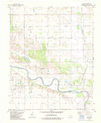
1982 Map of Lacey
USGS Topo · Published 1983About this map
The Cimarron River meanders through this portion of Kingfisher County, defining a landscape dominated by energy extraction and agriculture in the early 1980s. The region is marked by extensive industrial footprints, most notably the Lacey Oil and Gas Field and the Coronado Oil and Gas Field, which span large sections of the quadrangle north and south of the river. Small-scale aviation infrastructure, including the Bollenbach Landing Strip and the Huff Landing Strip, suggests the importance of private air travel in this rural corridor.
Find a feature on this map
13 named features on this map. Tap any name to fly to it.
Don’t see what you’re looking for? This feature index may not catch every label — zoom into the map to look around manually.
Map Details
Editions of this 1982 Lacey Map
This is the sole edition of this map. No revisions or reprints were ever made.
Other maps of this area

1892 · Kingfisher
USGS Topo · 1:125,000

1893 · Hennessey
USGS Topo · 1:62,500

1893 · Loyal
USGS Topo · 1:62,500

1893 · Ames
USGS Topo · 1:62,500

1895 · Kingfisher
USGS Topo · 1:125,000

1954 · Oklahoma City
USGS Topo · 1:250,000

1955 · Clinton
USGS Topo · 1:250,000

1955 · Enid
USGS Topo · 1:250,000

1955 · Woodward
USGS Topo · 1:250,000

1956 · Ames
USGS Topo · 1:62,500