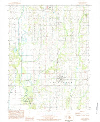
1984 Map of Laclede
USGS Topo · Published 1985About this map
Pershing State Park dominates the southwestern corner of this Linn County landscape, preserving a segment of the wetlands and bottomlands adjacent to Locust Creek. The map documents the rural character of the region in the early 1980s, centered on the historic town of Laclede and the northern settlement of Linneus. The Burlington Northern railroad corridor cuts east-to-west through Laclede, following the local topography and crossing several tributaries such as Muddy Creek and Turkey Creek. Outside the primary towns, the terrain is defined by a network of drainage systems, including Strawberry Couch Br and Little Turkey Creek. This survey captures the area's agricultural and conservation footprint, recording local landmarks like the town's Sew Disp Ponds and various Cem sites that serve as primary points of interest for genealogists studying the families of Jefferson and Parsons townships.
Find a feature on this map
19 named features on this map. Tap any name to fly to it.
Don’t see what you’re looking for? This feature index may not catch every label — zoom into the map to look around manually.
Map Details
Editions of this 1984 Laclede Map
This is the sole edition of this map. No revisions or reprints were ever made.
Other maps of this area

1924 · Chula
USGS Topo · 1:62,500

1924 · Hale
USGS Topo · 1:62,500

1946 · Brookfield
USGS Topo · 1:62,500

1947 · Chula
USGS Topo · 1:62,500

1948 · Brookfield
USGS Topo · 1:62,500

1949 · Sumner
USGS Topo · 1:24,000

1949 · Rothville
USGS Topo · 1:24,000

1950 · Sumner
USGS Topo · 1:24,000

1950 · Rothville
USGS Topo · 1:24,000

1951 · Hale
USGS Topo · 1:62,500