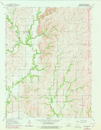
1964 Map of Laclede
USGS Topo · Published 1978About this map
Vermillion Creek carves a deep path through this Kansas landscape, serving as the central geographic feature for the community of Laclede. This survey, based on 1959 aerial photography and updated in the late 1970s, captures a rural agrarian network defined by its small cemeteries and watercourses. Genealogists will find several burial grounds noted, including Laclede Cem, Polly Creek Cem, and Vieux Cem, which provide specific points of reference for local families. The presence of a Gaging Station on Vermillion Creek and a major Pipeline indicates the local management of natural resources and infrastructure. The topography is further segmented by numerous drainages such as Pomeroy Creek, Indian Creek, and Lost Creek, which weave between the surveyed township boundaries of Center, Emmett, and Louisville.
Find a feature on this map
19 named features on this map. Tap any name to fly to it.
Don’t see what you’re looking for? This feature index may not catch every label — zoom into the map to look around manually.
Map Details
Editions of this 1964 Laclede Map
2 editions found
Other maps of this area

1889 · Wamego
USGS Topo · 1:125,000

1894 · Wamego
USGS Topo · 1:125,000

1953 · Wamego
USGS Topo · 1:24,000

1953 · Belvue
USGS Topo · 1:24,000

1953 · St Marys
USGS Topo · 1:24,000

1955 · Manhattan
USGS Topo · 1:250,000

1956 · Manhattan
USGS Topo · 1:250,000

1957 · Manhattan
USGS Topo · 1:250,000
1964 · Louisville
USGS Topo · 1:24,000
1964 · Onaga NE
USGS Topo · 1:24,000