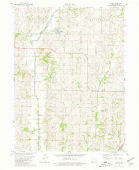
1980 Map of Ladoga
USGS Topo · Published 1981About this map
The One Hundred and Two River and its various forks dominate this southwestern Iowa landscape at the start of the 1980s. The small settlement of Ladoga sits in the northern section of the map, while the surrounding countryside is defined by agricultural boundaries and the winding paths of Brushy Creek and Daugherty Creek. Transport history is visible through the Old Railroad Grade and the Burlington Northern line, which follows the river's path. Local recreation and community landmarks are anchored by the Windmill Lake County Park and its accompanying Campground, while Graceland Cem serves as a genealogical marker for the area's families. The presence of a Quarry indicates the localized extraction of resources within this largely rural drainage basin.
Find a feature on this map
21 named features on this map. Tap any name to fly to it.
Don’t see what you’re looking for? This feature index may not catch every label — zoom into the map to look around manually.
Map Details
Editions of this 1980 Ladoga Map
This is the sole edition of this map. No revisions or reprints were ever made.
Other maps of this area

1940 · Bedford
USGS Topo · 1:62,500

1940 · New Market
USGS Topo · 1:62,500

1943 · Bedford
USGS Topo · 1:62,500

1943 · New Market
USGS Topo · 1:62,500

1955 · Nebraska City
USGS Topo · 1:250,000

1957 · Nebraska City
USGS Topo · 1:250,000

1958 · Nebraska City
USGS Topo · 1:250,000

1980 · Gravity
USGS Topo · 1:24,000
1980 · Hopkins SW
USGS Topo · 1:24,000

1980 · Guss
USGS Topo · 1:24,000