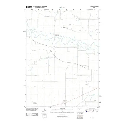
2010 Map of Ladora
USGS Topo · Published 2010About this map
The Iowa River meanders across this rural Iowa landscape, defining the northern geography between the small settlements of Dayton and Koszta. This agrarian region is characterized by its numerous small burial grounds and rural institutions, including the Seventh Day Adventist Church and several family-named landmarks like Sayers Cemetery and Kitchen Cemetery. The landscape transitions from the river valley into organized township grids, where the community of Ladora serves as a local hub near the southern edge, supported by the Ladora Post Office.
Find a feature on this map
46 named features on this map. Tap any name to fly to it.
Don’t see what you’re looking for? This feature index may not catch every label — zoom into the map to look around manually.
Map Details
Editions of this 2010 Ladora Map
This is the sole edition of this map. No revisions or reprints were ever made.
Other maps of this area

1954 · Des Moines
USGS Topo · 1:250,000

1956 · Des Moines
USGS Topo · 1:250,000

1957 · Des Moines
USGS Topo · 1:250,000

1965 · Ladora
USGS Topo · 1:24,000

1965 · Keystone South
USGS Topo · 1:24,000
1965 · Marengo
USGS Topo · 1:24,000
1965 · Blairstown
USGS Topo · 1:24,000
1968 · Williamsburg
USGS Topo · 1:24,000

1968 · Victor
USGS Topo · 1:24,000

1968 · Belle Plaine
USGS Topo · 1:24,000