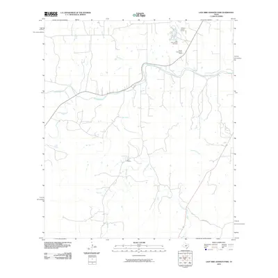
2010 Map of Lady Bird Johnson Park
USGS Topo · Published 2010About this map
The Pedernales River meanders across this Gillespie County landscape, serving as a primary geographic axis for the surrounding hill country. This 2010 survey illustrates the developed infrastructure of the Fredericksburg periphery, highlighted by the Gillespie County Airport and the community gathering point at the Wrede Community House. The integration of public recreation and local history is evident at the Lady Bird Johnson Park Dam, situated where Live Oak Creek meets the river's path.
Find a feature on this map
14 named features on this map. Tap any name to fly to it.
Don’t see what you’re looking for? This feature index may not catch every label — zoom into the map to look around manually.
Map Details
Editions of this 2010 Lady Bird Johnson Park Map
This is the sole edition of this map. No revisions or reprints were ever made.
Other maps of this area

1894 · Fredericksburg
USGS Topo · 1:125,000

1894 · Kerrville
USGS Topo · 1:125,000

1954 · Llano
USGS Topo · 1:250,000

1955 · Llano
USGS Topo · 1:250,000

1956 · Llano
USGS Topo · 1:250,000

1963 · Cain City
USGS Topo · 1:24,000

1964 · Oak Crest Park
USGS Topo · 1:24,000

1964 · Morris Ranch
USGS Topo · 1:24,000
1964 · Rafter Hollow
USGS Topo · 1:24,000
1964 · Cypress Creek
USGS Topo · 1:24,000