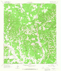
1964 Map of Cypress Creek
USGS Topo · Published 1966About this map
Cypress Creek meanders through the divide between Kerr and Kendall counties, carving a landscape defined by prominent peaks and numerous natural water sources. This 1964 survey, conducted before modern development altered the ranching corridors, shows the concentration of local life around family-named operations like Cypress Ranch and Hasenwinkel Ranch. The terrain is punctuated by significant landmarks including Broad Mountain and Pointed Mountain, while the named valleys of Elm Valley and Apple Valley suggest a history of agricultural diversification in the Texas Hill Country.
Find a feature on this map
35 named features on this map. Tap any name to fly to it.
Don’t see what you’re looking for? This feature index may not catch every label — zoom into the map to look around manually.
Map Details
Editions of this 1964 Cypress Creek Map
3 editions found
Other maps of this area

1894 · Fredericksburg
USGS Topo · 1:125,000

1894 · Kerrville
USGS Topo · 1:125,000

1954 · Llano
USGS Topo · 1:250,000

1954 · San Antonio
USGS Topo · 1:250,000

1955 · Llano
USGS Topo · 1:250,000

1956 · Comfort
USGS Topo · 1:62,500

1956 · Center Point
USGS Topo · 1:62,500

1956 · Llano
USGS Topo · 1:250,000

1957 · San Antonio
USGS Topo · 1:250,000

1963 · Cain City
USGS Topo · 1:24,000