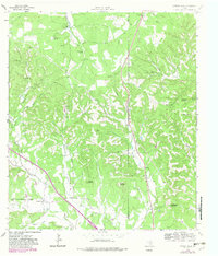
1964 Map of Cypress Creek
USGS Topo · Published 1982About this map
The rugged drainage systems of the Texas Hill Country dominate this 1964 survey, where Cypress Creek and North Creek carve through a landscape of high ridges and named peaks. The terrain is marked by distinct summits such as Pointed Mountain, Broad Mountain, and Rattlesnake Mountain, with numerous springs like Dipping Vat Spring and Sycamore Spring providing critical water sources for local ranching. The presence of Hasenwinkel Ranch and Turkey Hollow Ranch indicates the late-century land use patterns in this part of Kerr Co and Kendall Co.
Find a feature on this map
33 named features on this map. Tap any name to fly to it.
Don’t see what you’re looking for? This feature index may not catch every label — zoom into the map to look around manually.
Map Details
Editions of this 1964 Cypress Creek Map
3 editions found
Other maps of this area

1894 · Fredericksburg
USGS Topo · 1:125,000

1894 · Kerrville
USGS Topo · 1:125,000

1954 · Llano
USGS Topo · 1:250,000

1954 · San Antonio
USGS Topo · 1:250,000

1955 · Llano
USGS Topo · 1:250,000

1956 · Comfort
USGS Topo · 1:62,500

1956 · Center Point
USGS Topo · 1:62,500

1956 · Llano
USGS Topo · 1:250,000

1957 · San Antonio
USGS Topo · 1:250,000

1963 · Cain City
USGS Topo · 1:24,000