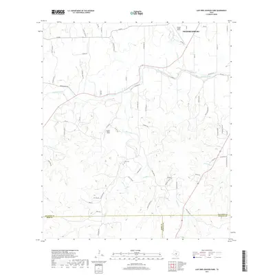
2019 Map of Lady Bird Johnson Park
USGS Topo · Published 2019About this map
Fredericksburg serves as the focal point in the northeastern corner of this terrain, where the suburban edge meets the Texas Hill Country. The landscape is defined by the winding course of the Pedernales River, which draws in several major tributaries including Live Oak Cr and Wolf Cr. The map reveals a complex network of ranch roads and family-named routes such as Morris Ranch Rd and Kneese Parrish Rd, reflecting the area's agricultural legacy and ongoing rural development. Aviation footprints are prominent with both the Gillespie County Airport and the smaller Cameron Ranch Airport located nearby. Evidence of early settlement remains visible through the Eckert Cem and the former alignment of the Old Kerr Hwy, while the southern portion of the map is dominated by the rugged drainages of Bear Creek and Muesebach Cr near the boundary of Kendall and Gillespie counties.
Find a feature on this map
68 named features on this map. Tap any name to fly to it.
Don’t see what you’re looking for? This feature index may not catch every label — zoom into the map to look around manually.
Map Details
Editions of this 2019 Lady Bird Johnson Park Map
This is the sole edition of this map. No revisions or reprints were ever made.
Other maps of this area

1894 · Fredericksburg
USGS Topo · 1:125,000

1894 · Kerrville
USGS Topo · 1:125,000

1954 · Llano
USGS Topo · 1:250,000

1955 · Llano
USGS Topo · 1:250,000

1956 · Llano
USGS Topo · 1:250,000

1963 · Cain City
USGS Topo · 1:24,000

1964 · Oak Crest Park
USGS Topo · 1:24,000

1964 · Morris Ranch
USGS Topo · 1:24,000
1964 · Rafter Hollow
USGS Topo · 1:24,000
1964 · Cypress Creek
USGS Topo · 1:24,000