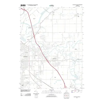
2010 Map of Lafayette East
USGS Topo · Published 2010About this map
The Wabash River and the complex drainage system of Wildcat Creek define the eastern reach of this Indiana landscape. In the early 21st century, the area shows a distinct transition from the dense urban grid of eastern Lafayette to the smaller outlying communities like Dayton and Buck Creek. Local aviation is prominent across the terrain, with Aretz Airport, Halsmer Airport, and the Wildcat Air Landing Area all serving the region. The map preserves the locations of numerous historic burial sites, including the Swisher-Hurtz Cemetery and North Union Cemetery, which provide valuable anchors for genealogical research. The infrastructure of the era is evident in the heavy industrial and residential development concentrated near Eastwitch and Tecumseh, while the eastern portion of the sheet retains its agrarian character, punctuated by landmarks such as the Union Cemetery and the rural settlement of Monitor.
Find a feature on this map
54 named features on this map. Tap any name to fly to it.
Don’t see what you’re looking for? This feature index may not catch every label — zoom into the map to look around manually.
Map Details
Editions of this 2010 Lafayette East Map
This is the sole edition of this map. No revisions or reprints were ever made.
Other maps of this area

1941 · Lafayette
USGS Topo · 1:24,000

1942 · Lafayette
USGS Topo · 1:24,000

1950 · Lafayette
USGS Topo · 1:24,000

1953 · Danville
USGS Topo · 1:250,000

1955 · Danville
USGS Topo · 1:250,000

1956 · Danville
USGS Topo · 1:250,000

1961 · Mulberry
USGS Topo · 1:24,000

1961 · Pyrmont
USGS Topo · 1:24,000

1961 · Romney
USGS Topo · 1:24,000

1961 · Stockwell
USGS Topo · 1:24,000