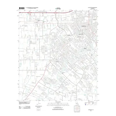
2012 Map of Lafayette
USGS Topo · Published 2012About this map
The Vermilion River and a network of drainage coulees, including Coulee Ile des Cannes and Coulee Mine, define the landscape of this southern Louisiana hub. In the early 21st century, the expansion of Lafayette and neighboring Scott is evident through dense residential developments like Broadmoor and the Arbolada Addition. The influence of the University of Louisiana Lafayette is prominent, centered around Cajun Field.
Find a feature on this map
57 named features on this map. Tap any name to fly to it.
Don’t see what you’re looking for? This feature index may not catch every label — zoom into the map to look around manually.
Map Details
Editions of this 2012 Lafayette Map
This is the sole edition of this map. No revisions or reprints were ever made.
Other maps of this area

1934 · Duson
USGS Topo · 1:31,680

1939 · St. Martinsville
USGS Topo · 1:62,500

1940 · Arnaudville
USGS Topo · 1:62,500

1946 · Milton
USGS Topo · 1:31,680

1946 · Leroy
USGS Topo · 1:31,680

1946 · Lafayette
USGS Topo · 1:31,680

1952 · Lake Charles
USGS Topo · 1:250,000

1954 · Lafayette
USGS Topo · 1:31,680

1954 · Duson
USGS Topo · 1:31,680
1954 · Leroy
USGS Topo · 1:31,680