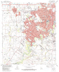
1983 Map of Lafayette
USGS Topo · Published 1983About this map
The Vermilion River and Vermilion Bayou anchor this urban and industrial landscape of the early 1980s, documenting the dense growth of Lafayette and the neighboring town of Scott. The map reveals a robust educational and religious infrastructure, including the University of Southwestern Louisiana and numerous parochial institutions like Immaculate Heart of Mary Sch and Our Lady of Fatima Sch. For genealogists, the sheet is exceptionally detailed, locating small family and parish burial grounds such as Simon Cem, Cobb Cem, and Holy Sepulchre Cem.
Find a feature on this map
65 named features on this map. Tap any name to fly to it.
Don’t see what you’re looking for? This feature index may not catch every label — zoom into the map to look around manually.
Map Details
Editions of this 1983 Lafayette Map
This is the sole edition of this map. No revisions or reprints were ever made.
Other maps of this area

1934 · Duson
USGS Topo · 1:31,680

1939 · St. Martinsville
USGS Topo · 1:62,500

1940 · Arnaudville
USGS Topo · 1:62,500

1946 · Milton
USGS Topo · 1:31,680

1946 · Leroy
USGS Topo · 1:31,680

1946 · Lafayette
USGS Topo · 1:31,680

1952 · Lake Charles
USGS Topo · 1:250,000

1954 · Lafayette
USGS Topo · 1:31,680

1954 · Duson
USGS Topo · 1:31,680
1954 · Leroy
USGS Topo · 1:31,680