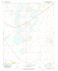
1978 Map of Laguna Del Perro North
USGS Topo · Published 1978About this map
The Laguna Del Perro dominates this arid landscape in Torrance County, where a chain of ephemeral salt pans stretches across the basin floor. This 1978 survey captures the high-desert terrain during a period of steady industrial transit, defined by the prominent diagonal path of the Atchison Topeka and Santa Fe railroad. The line cuts directly through the lake bed area, reflecting the historic importance of this corridor for transcontinental freight. Beyond the rails and white lake beds, signs of subterranean exploration appear in the form of a Drill Hole, suggesting mineral or geological surveying efforts in this sparsely populated region of New Mexico. The map provides a detailed view of the natural depressions and drainage patterns that characterize the Estancia Basin's unique hydrology.
Find a feature on this map
4 named features on this map. Tap any name to fly to it.
Don’t see what you’re looking for? This feature index may not catch every label — zoom into the map to look around manually.
Map Details
Editions of this 1978 Laguna Del Perro North Map
2 editions found
Other maps of this area

1917 · Estancia
USGS Topo · 1:125,000

1954 · Fort Sumner
USGS Topo · 1:250,000

1954 · Socorro
USGS Topo · 1:250,000

1956 · Estancia
USGS Topo · 1:62,500

1956 · Mountainair
USGS Topo · 1:62,500

1958 · Socorro
USGS Topo · 1:250,000

1958 · Fort Sumner
USGS Topo · 1:250,000

1960 · Lobo Hill
USGS Topo · 1:62,500

1962 · Socorro
USGS Topo · 1:250,000

1978 · Laguna Del Perro North
USGS Topo · 1:24,000