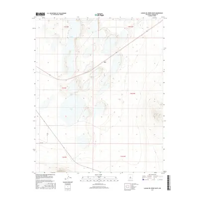
2017 Map of Laguna Del Perro South
USGS Topo · Published 2017About this map
Laguna del Perro and Salina Lake anchor this arid landscape within the Estancia Basin, where salt crusts and playa lakes define the local geography. The settlement of Silio sits north of a significant curve in U.S. Route 60, representing a small human footprint in a region dominated by these natural salt basins. The map illustrates a transition from the level lake beds to the rising elevations of the surrounding terrain, marked by the meticulous contouring of the National Elevation Dataset. Rural access is maintained via Co Rd B 091, which connects the open range to the primary highway corridor. This 2017 survey reflects the enduring character of this part of Torrance County, where the infrastructure is sparse and the environmental features remain the most prominent landmarks.
Find a feature on this map
12 named features on this map. Tap any name to fly to it.
Don’t see what you’re looking for? This feature index may not catch every label — zoom into the map to look around manually.
Map Details
Editions of this 2017 Laguna Del Perro South Map
This is the sole edition of this map. No revisions or reprints were ever made.
Other maps of this area

1917 · Estancia
USGS Topo · 1:125,000

1954 · Fort Sumner
USGS Topo · 1:250,000

1954 · Socorro
USGS Topo · 1:250,000

1956 · Mountainair
USGS Topo · 1:62,500

1958 · Socorro
USGS Topo · 1:250,000

1958 · Fort Sumner
USGS Topo · 1:250,000

1962 · Socorro
USGS Topo · 1:250,000
1972 · Round Top
USGS Topo · 1:24,000

1978 · Laguna Del Perro North
USGS Topo · 1:24,000

1978 · Laguna Del Perro South
USGS Topo · 1:24,000