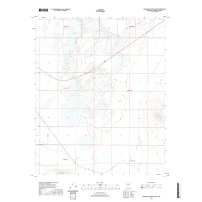
2020 Map of Laguna Del Perro South
USGS Topo · Published 2020About this map
Silio sits at the junction of Highway 60 and Highway 42 within the arid Estancia Basin of Torrance County. This modern survey illustrates a landscape dominated by internal drainage, where the topography is defined by the significant ephemeral water bodies of Laguna del Perro and Salina Lake. These salt basins, or playas, are characteristic of the region's closed-basin geography, where water accumulates in shallow depressions before evaporating, leaving behind mineral-rich lake beds. The map details the local infrastructure supporting this rural New Mexico environment, including Co Rd B091, which provides access through the expansive sections of the Public Land Survey System, marked by township and range lines like t5n r9e and t4n r10e.
Find a feature on this map
13 named features on this map. Tap any name to fly to it.
Don’t see what you’re looking for? This feature index may not catch every label — zoom into the map to look around manually.
Map Details
Editions of this 2020 Laguna Del Perro South Map
This is the sole edition of this map. No revisions or reprints were ever made.
Other maps of this area

1917 · Estancia
USGS Topo · 1:125,000

1954 · Fort Sumner
USGS Topo · 1:250,000

1954 · Socorro
USGS Topo · 1:250,000

1956 · Mountainair
USGS Topo · 1:62,500

1958 · Socorro
USGS Topo · 1:250,000

1958 · Fort Sumner
USGS Topo · 1:250,000

1962 · Socorro
USGS Topo · 1:250,000
1972 · Round Top
USGS Topo · 1:24,000

1978 · Laguna Del Perro North
USGS Topo · 1:24,000

1978 · Laguna Del Perro South
USGS Topo · 1:24,000