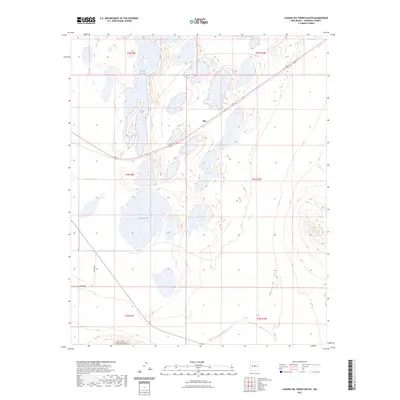
2023 Map of Laguna Del Perro South
USGS Topo · Published 2023About this map
Salina Lake and the southern reaches of Laguna del Perro define this Torrance County landscape, where the Estancia Valley's salt basins have long shaped local geography. The settlement of Silio sits near the intersection of several township boundaries, including t4n r9e and t4n r10e, marking a small point of habitation in a region dominated by these seasonal alkali lakes. Grounded in 2020 imagery and updated to contemporary standards, the map traces the path of Highway 60 as it cuts across the center of the quadrangle. Local routes such as Co Rd B 091 provide access to the surrounding rangeland, reflecting the sparse, utilitarian road network of this central New Mexico basin.
Find a feature on this map
12 named features on this map. Tap any name to fly to it.
Don’t see what you’re looking for? This feature index may not catch every label — zoom into the map to look around manually.
Map Details
Editions of this 2023 Laguna Del Perro South Map
This is the sole edition of this map. No revisions or reprints were ever made.
Other maps of this area

1917 · Estancia
USGS Topo · 1:125,000

1954 · Fort Sumner
USGS Topo · 1:250,000

1954 · Socorro
USGS Topo · 1:250,000

1956 · Mountainair
USGS Topo · 1:62,500

1958 · Socorro
USGS Topo · 1:250,000

1958 · Fort Sumner
USGS Topo · 1:250,000

1962 · Socorro
USGS Topo · 1:250,000
1972 · Round Top
USGS Topo · 1:24,000

1978 · Laguna Del Perro North
USGS Topo · 1:24,000

1978 · Laguna Del Perro South
USGS Topo · 1:24,000