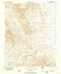
1956 Map of Laguna Seca Ranch
USGS Topo · Published 1957About this map
Laguna Seca Ranch and Barneich Ranch anchor this mid-century look at the eastern edge of the Diablo Range where it meets the Central Valley. The landscape is defined by the significant hydrological management required for ranching in this arid environment, evidenced by numerous Water Tanks, Reservoirs, and Springs tucked into the folds of the Panoche Hills. The rugged topography of Salt Canyon and Wildcat Canyon drains toward the Little Panoche Valley, where Little Panoche Creek winds through the basin. A prominent Pipeline cuts across the northeastern corner, marking the early infrastructure of the San Joaquin Valley. This 1950s survey captures the area before modern agricultural shifts, when the Merced Co Fresno Co boundary was primarily occupied by wide-open ranch land and seasonal creek beds.
Find a feature on this map
13 named features on this map. Tap any name to fly to it.
Don’t see what you’re looking for? This feature index may not catch every label — zoom into the map to look around manually.
Map Details
Editions of this 1956 Laguna Seca Ranch Map
4 editions found
Other maps of this area

1913 · Panoche
USGS Topo · 1:125,000

1920 · Carrisalito Spring
USGS Topo · 1:31,680

1921 · Laguna Seca Ranch
USGS Topo · 1:31,680

1921 · Tierra Loma School
USGS Topo · 1:31,680

1922 · Charleston School
USGS Topo · 1:31,680

1922 · Dos Palos
USGS Topo · 1:31,680

1922 · Ortigalita
USGS Topo · 1:31,680

1923 · Laguna Seca Ranch
USGS Topo · 1:31,680

1923 · Tierra Loma School
USGS Topo · 1:31,680

1923 · Little Panoche
USGS Topo · 1:31,680