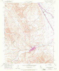
1956 Map of Laguna Seca Ranch
USGS Topo · Published 1972About this map
The Merced Co Fresno Co line divides this landscape of western San Joaquin Valley foothills, dominated by large-scale ranching and critical water infrastructure. Laguna Seca Ranch and Barneich Ranch anchor the local geography, representing the historical livestock operations of this arid region. The terrain is defined by the Panoche Hills and the winding course of Little Panoche Creek, which feeds into the Little Panoche Reservoir.
Find a feature on this map
19 named features on this map. Tap any name to fly to it.
Don’t see what you’re looking for? This feature index may not catch every label — zoom into the map to look around manually.
Map Details
Editions of this 1956 Laguna Seca Ranch Map
4 editions found
Other maps of this area

1913 · Panoche
USGS Topo · 1:125,000

1920 · Carrisalito Spring
USGS Topo · 1:31,680

1921 · Laguna Seca Ranch
USGS Topo · 1:31,680

1921 · Tierra Loma School
USGS Topo · 1:31,680

1922 · Charleston School
USGS Topo · 1:31,680

1922 · Dos Palos
USGS Topo · 1:31,680

1922 · Ortigalita
USGS Topo · 1:31,680

1923 · Laguna Seca Ranch
USGS Topo · 1:31,680

1923 · Tierra Loma School
USGS Topo · 1:31,680

1923 · Little Panoche
USGS Topo · 1:31,680