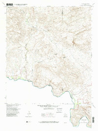
1971 Map of Lajitas
USGS Topo · Published 1985About this map
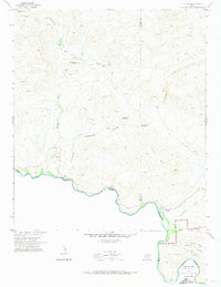
The Rio Grande carves a sharp international boundary between Texas and Mexico on this 1971 study of the Big Bend region. The settlement of Lajitas sits near the river's edge, marked by a nearby Cem and Landing Strip. To the north, the landscape is defined by the unique geological formation of the Wax Factory Laccolith and the deep cuts of Fresno Canyon. Industrial activity is evident through the Whitney Mine and Fresno Mine, while the southern portion of the sheet transitions into the protected lands of Big Bend National Park. This desert terrain is crisscrossed by paths such as the Contrabando Trail and a Pack Trail, linking isolated sites like Madrid Ranch and unidentified Ruins near the riverbanks. The prevalence of labels like Prospect and Contrabando Waterhole suggests a history of resource extraction and a reliance on scarce water sources like Fresno Creek.
Find a feature on this map
35 named features on this map. Tap any name to fly to it.
Don’t see what you’re looking for? This feature index may not catch every label — zoom into the map to look around manually.
Map Details
Editions of this 1971 Lajitas Map
3 editions found
Other maps of this area

1903 · Terlingua
USGS Topo · 1:125,000

1904 · Terlingua
USGS Topo · 1:125,000

1931 · Lajitas
USGS Topo · 1:62,500

1959 · Emory Peak
USGS Topo · 1:250,000

1965 · Emory Peak
USGS Topo · 1:250,000

1971 · Yellow Hill
USGS Topo · 1:24,000

1971 · Amarilla Mountain
USGS Topo · 1:24,000
1971 · The Solitario
USGS Topo · 1:24,000
1971 · Sauceda Ranch
USGS Topo · 1:24,000
1971 · Lajitas
USGS Topo · 1:24,000