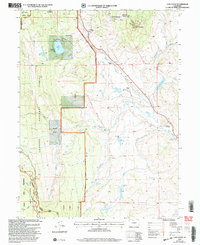
2000 Map of Lake Agnes
USGS Topo · Published 2004About this map
The Continental Divide winds through the high alpine terrain of north-central Colorado, separating the drainage basins that define this portion of the Routt National Forest and Arapaho National Forest. High-elevation landmarks like Baker Mountain and the Rabbit Ears Range loom over a landscape where early industry and ranching met wilderness. The presence of the Smokey Sawmill and various gravel pits suggest the localized extraction of timber and stone, while isolated ranching outposts like Anderson Ranch and De Berard Peak Ranch highlight the settlement patterns of these remote mountain valleys at the turn of the millennium.
Find a feature on this map
36 named features on this map. Tap any name to fly to it.
Don’t see what you’re looking for? This feature index may not catch every label — zoom into the map to look around manually.
Map Details
Editions of this 2000 Lake Agnes Map
This is the sole edition of this map. No revisions or reprints were ever made.
Other maps of this area

1954 · Craig
USGS Topo · 1:250,000

1956 · Rabbit Ears Peak
USGS Topo · 1:24,000

1956 · Lake Agnes
USGS Topo · 1:24,000

1956 · Kremmling
USGS Topo · 1:62,500

1956 · Spicer Peak
USGS Topo · 1:24,000

1956 · Whiteley Peak
USGS Topo · 1:24,000

1956 · Storm Mountain
USGS Topo · 1:24,000

1956 · Walton Peak
USGS Topo · 1:24,000

1956 · Gore Pass
USGS Topo · 1:62,500

1956 · Hyannis Peak
USGS Topo · 1:62,500