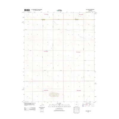
2013 Map of Lake Albert
USGS Topo · Published 2013About this map
Lake Albert lies at the southern edge of this High Plains landscape, a terminal basin in a region defined by its ephemeral drainage patterns. The topography is shaped by the wandering courses of S Fork White Woman Cr and White Woman Cr, which cut through the tablelands of the Colorado borderlands. This 2013 survey provides a clear view of the section line road network, including CO Road A and CO Road 75, which follow the rigid grid of the Public Land Survey System. The boundary between Cheyenne Co and Kiowa Co bisects the northern half of the sheet, illustrating how political lines were drawn across this open terrain. The map's detail is essential for understanding the hydrology of this semi-arid environment, where water features like the South Fork determine the character of the surrounding land.
Find a feature on this map
20 named features on this map. Tap any name to fly to it.
Don’t see what you’re looking for? This feature index may not catch every label — zoom into the map to look around manually.
Map Details
Editions of this 2013 Lake Albert Map
This is the sole edition of this map. No revisions or reprints were ever made.
Other maps of this area

1890 · Granada
USGS Topo · 1:125,000

1892 · Cheyenne Wells
USGS Topo · 1:125,000

1892 · Granada
USGS Topo · 1:125,000

1894 · Cheyenne Wells
USGS Topo · 1:125,000

1894 · Granada
USGS Topo · 1:125,000

1954 · Lamar
USGS Topo · 1:250,000

1958 · Lamar
USGS Topo · 1:250,000

1968 · Stuart
USGS Topo · 1:24,000

1968 · Sheridan Lake
USGS Topo · 1:24,000
1968 · Towner
USGS Topo · 1:24,000